
Tino to still bring rains to Palawan, Mindoro, other areas even after exiting PAR
Typhoon Kalmaegi (local name: Tino) is likely to continue bringing rain to Palawan, Mindoro, and other areas even after exiting the Philippine Area of Responsibility (PAR) early Thursday morning, according to the Philippine Atmospheric, Geophysical and Astronomical Services Administration (PAGASA).
“Due to the trough or extension of Typhoon Tino, scattered rain showers are still possible over Palawan and Occidental Mindoro,” PAGASA weather specialist Chenel Dominguez said during a 5:00 a.m. advisory.
The same weather condition is also expected in areas of Aurora and Quezon Province due to the typhoon’s trough.
A trough of a typhoon is an extended band of clouds and winds that stretches outward from the storm’s center, causing rain and thunderstorms in affected areas.
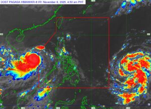
Kalmaegi has maintained its typhoon strength even after multiple landfalls, packing sustained winds of 155 kilometers per hour (kph) and gusts of up to 190 kph, PAGASA said in its 5:00 a.m. bulletin.
It was last spotted 265 kilometers north-northwest of Pagasa Island, Kalayaan, Palawan, moving west-northwest at 35 kph.
PAGASA has lifted almost all Tropical Cyclone Wind Signals hoisted in more than a dozen areas, except Signal No. 1, which remains in effect over the Kalayaan Islands where minimal to minor wind impacts are expected.
Kalmaegi is expected to move farther away from the country and make landfall in Vietnam by early Friday morning. — Edg Adrian A. Eva