
Paolo intensifies into typhoon, slams Isabela
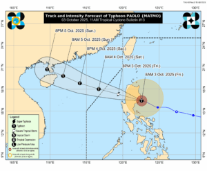
Tropical Cyclone Matmo, locally named Paolo, has intensified into a typhoon category and made its first landfall over Dinapigue, Isabela, according to the state weather bureau on Friday.
“At 9:00 a.m. today, the center of Typhoon Paolo has made landfall over Dinapigue, Isabela,” the Philippine Atmospheric, Geophysical and Astronomical Services Administration (PAGASA) said in its latest advisory.
Afterwards, PAGASA said that the typhoon is expected to cross large parts of Cagayan Valley, the Cordillera region, and the Ilocos region from Friday morning until afternoon, before reaching the West Philippine Sea by early evening.
Paolo has maximum sustained winds of 130 kilometers per hour (kph) near its eye and gustiness of 180 kph, moving west-northwestward at 25 kph, according to PAGASA’s 8:00 am advisory.
Tropical Wind Signal No. 3, bearing strong force winds, was hoisted in the northern portion of Aurora, the central and southern portions of Isabela, the northern portion of Quirino, the northern portion of Nueva Vizcaya, Mountain Province, and Ifugao.
It is likewise in effect in the southeastern portion of Abra, the northern portion of Benguet, the central and southern portions of Ilocos Sur, and the northern portion of La Union.
Signal No. 2, bringing gale force winds, was raised in the central and southern portions of mainland Cagayan, the rest of Isabela, the rest of Quirino, the rest of Nueva Vizcaya, the central portion of Aurora, the northern portion of Nueva Ecija, the central and southern portions of Apayao, Kalinga, the rest of Abra, the rest of Benguet, the central and southern portions of Ilocos Norte, the rest of Ilocos Sur, the rest of La Union, and the northern portion of Pangasinan.
Meanwhile, Signal No. 1 was declared in the rest of mainland Cagayan including Babuyan Islands, the rest of Aurora, the northern portion of Quezon including Polillo Islands, Camarines Norte, the northern portion of Camarines Sur, Catanduanes, the rest of Apayao, the rest of Ilocos Norte, the rest of Pangasinan, the rest of Nueva Ecija, the northern portion of Bulacan, Tarlac, the northeastern portion of Pampanga, and the northern portion of Zambales.
PAGASA also raised a storm surge warning in various areas primarily in Aurora, Cagayan, Ilocos Norte, Isabela where 2.1 to 3 meters of surge may occur.
The public is advised to avoid going near coasts or beaches along the storm’s path, as well as to refrain from any type of marine activity. PAGASA also reiterated warnings on the possibility of flooding and landslides, especially in areas that are highly prone to these hazards. — Edg Adrian A. Eva