
LPA monitored outside PAR
THE STATE weather bureau on Thursday said a low pressure area (LPA) that it is monitoring outside the Philippines’ area of responsibility (PAR) had a low chance of developing into a tropical depression. The LPA was last located 370 kilometers northwest of Pag-asa Island in Kalayaan, Palawan at 8 a.m. on Thursday, the Philippine Atmospheric, […]
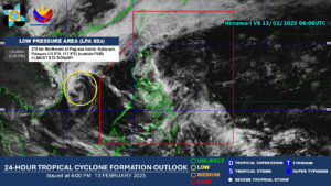
THE STATE weather bureau on Thursday said a low pressure area (LPA) that it is monitoring outside the Philippines’ area of responsibility (PAR) had a low chance of developing into a tropical depression.
The LPA was last located 370 kilometers northwest of Pag-asa Island in Kalayaan, Palawan at 8 a.m. on Thursday, the Philippine Atmospheric, Geophysical and Astronomical Services Administration (PAGASA) said in a report.
It has a low chance of developing into a tropical depression within the next 24 hours, it added.
PAGASA is also monitoring the shear line affecting Northern Luzon, and the Intertropical Convergence Zone (ITCZ), which is influencing the weather in Mindanao.
It said the shear line may cause cloudy skies with scattered rain and isolated thunderstorms in Batanes and the Babuyan Islands.
PAGASA flagged possible flash floods or landslides.
It said the ITCZ may result in cloudy skies with scattered rain and thunderstorms in Caraga, the Davao Region, Camiguin, Misamis Oriental, and Bukidnon. It also flagged possible flash floods or landslides.
Meanwhile, PAGASA said the Visayas, Bicol Region, and Romblon may experience cloudy skies with scattered rain and thunderstorms due to the easterlies.
Easterlies could also cause partly cloudy to cloudy skies with thunderstorms in Metro Manila and other parts of the country. — Kyle Aristophere T. Atienza