Nika intensifies to typhoon, Signal No. 4 raised in Isabela and Aurora
Nika has further intensified into a typhoon as it approaches the boundary of Isabela and Aurora, prompting the declaration of Tropical Cyclone Wind Signal No. 4 in various areas of Luzon, the state weather bureau announced on Monday morning. In a weather advisory released by the Philippine Atmospheric, Geophysical and Astronomical Services Administration (PAGASA) at […]

Nika has further intensified into a typhoon as it approaches the boundary of Isabela and Aurora, prompting the declaration of Tropical Cyclone Wind Signal No. 4 in various areas of Luzon, the state weather bureau announced on Monday morning.
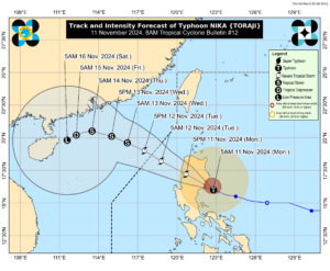
In a weather advisory released by the Philippine Atmospheric, Geophysical and Astronomical Services Administration (PAGASA) at 8:00 a.m. on Monday, the eye of Typhoon Nika was estimated to be located 100 km east-southeast of Casiguran, Aurora (16.0°N, 123.0°E), moving west northwestward at a speed of 15 km/h.
Nika now has a maximum sustained winds of 130 km/h near the center, with gusts of up to 180km/h.
PAGASA reported that Typhoon Nika is expected to make landfall over Isabela or northern Aurora this morning. The storm will then cross mainland Luzon throughout Monday and is forecast to emerge over the waters west of Ilocos Sur by Monday evening.
Wind Signal No. 4 is currently in effect in the northernmost portion of Aurora, the central and southern portions of Isabela, Kalinga, Mountain Province, the northern portion of Ifugao, the central and southern portions of Abra, and the northern and central portions of Ilocos Sur, where winds of 118 km/h to 184 km/h are expected within the next 12 hours. PAGASA warned that significant and severe impacts could occur under this wind signal.
Wind Signal No. 3 is in effect for the central portion of Aurora, the northern portion of Quirino, the northeastern portion of Nueva Vizcaya, the rest of Isabela, the southwestern portion of Cagayan, the rest of Abra, the rest of Ifugao, the northern portion of Benguet, the southern portion of Ilocos Norte, and the rest of Ilocos Sur. Winds of 89 km/h to 117 km/h are expected within the next 18 hours, potentially causing moderate to significant impacts.
Wind Signal No. 2 has been raised for the northwestern and eastern portions of Cagayan, the rest of Nueva Vizcaya, the rest of Quirino, the rest of Apayao, the rest of Benguet, the rest of Ilocos Norte, La Union, the northeastern portion of Pangasinan, the central portion of Aurora, and the northern portion of Nueva Ecija. Winds of 62 km/h to 88 km/h are expected within the next 24 hours, potentially causing minor to moderate impacts.
Wind Signal No. 1 has been raised for the rest of mainland Cagayan, the rest of Pangasinan, the rest of Aurora, the rest of Nueva Ecija, Bulacan, Pampanga, Tarlac, the northern and central portions of Zambales, Metro Manila, Rizal, the eastern portion of Laguna, the northern and eastern portions of Quezon, Polillo Islands, and the northwestern portion of Camarines Norte. Winds of 39 km/h to 61 km/h are expected within the next 36 hours, potentially causing minimal to minor impacts.
Typhoon Nika may also cause “moderate to high risk of storm surge within the next 48 hours,” according to PAGASA, particularly in low-lying or exposed coastal areas of Ilocos Norte, Ilocos Sur, La Union, Pangasinan, Cagayan (including the Babuyan Islands), Isabela, Zambales, Aurora, Quezon (including the Polillo Islands), Camarines Norte, and Camarines Sur.
According to PAGASA’s track and intensity forecast, Typhoon Nika is expected to move generally west-northwestward until Thursday, then shift southwestward starting Friday. The typhoon is also forecast to exit the Philippine Area of Responsibility by Tuesday morning or afternoon. – Edg Adrian A. Eva


